
Dallas-Fort Worth Weather: A Shifting Pattern of Heat and Humidity
The weather in North Texas is on the cusp of a significant transition, as the remnants of summer give way to a hint of fall. As of September 5, 2025, the region is experiencing a continuation of late-summer conditions, with high temperatures expected to hover in the low to mid-90s. The average high for this time of year is around 92 degrees, so we’re right on schedule for some typical Texas heat. However, an upper-level disturbance is on its way, bringing with it the potential for some impactful weather changes. So, what does this mean for your plans today and into the weekend? The answer, as always, is complicated but manageable. Are you ready for a bit of a weather rollercoaster? Let’s dive in!
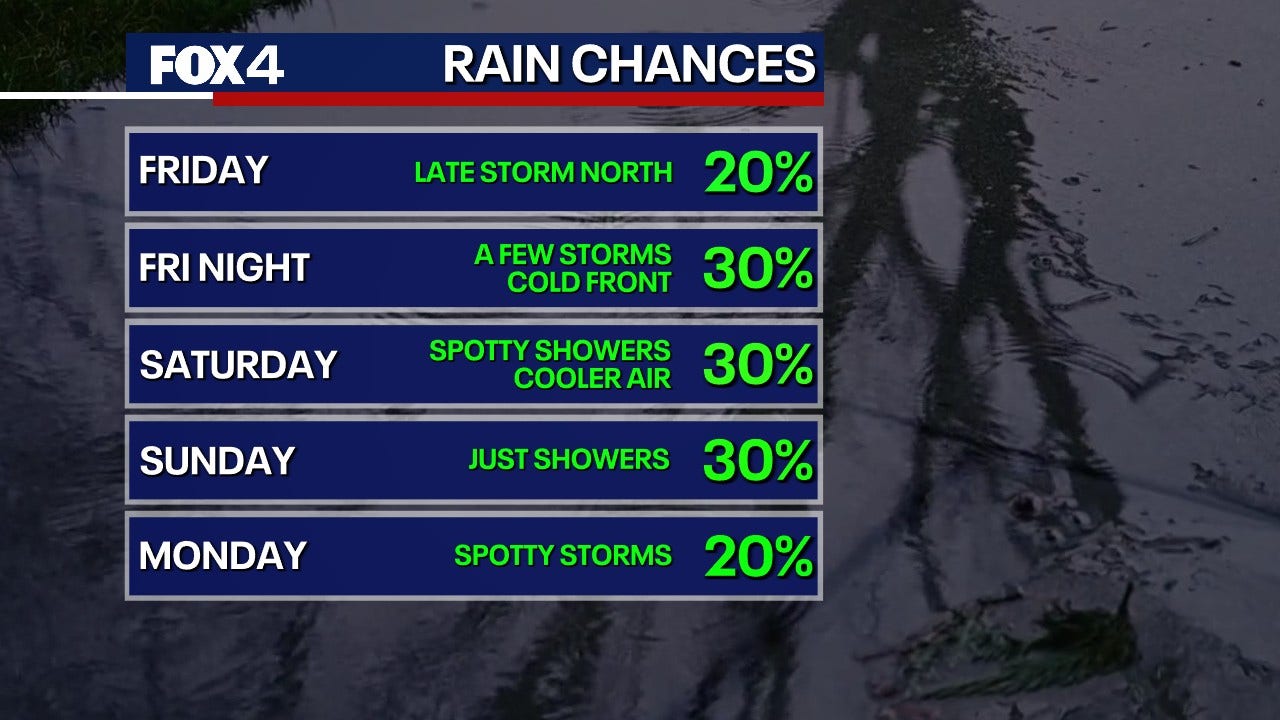
The primary focus of today’s forecast is the arrival of a cold front, which will usher in a chance of thunderstorms. The National Weather Service and meteorologist Evan Andrews are predicting a 30% chance of storms this afternoon. These storms are not expected to be mere rain showers, but rather they could pack a punch, with strong winds potentially reaching 50 to 60 mph and the possibility of small hail. Where should you be most watchful? The highest concentration of storms is expected to develop north of the Dallas-Fort Worth area. So if you live or work in that area, keep an eye on the sky. Showers and storms will gradually spread southward overnight, though they are anticipated to lose some of their intensity. In short, prepare for a late-day weather shift and plan accordingly.
Today’s Outlook: Warm Temperatures with a Chance of Thunderstorms
What can you expect for the rest of the day? High temperatures will likely stay in the low to mid-90s. However, don’t expect those triple-digit readings that can sometimes plague us, as some upper-level cloudiness may dim the sun a bit. This will prevent the mercury from climbing too high. The main event of the day, however, will be the approaching thunderstorms. These storms are fueled by an upper-level disturbance that’s moving into North Texas. The potential for strong winds and hail means it’s a good idea to stay informed about any weather alerts. Make sure you have a way to receive weather updates, whether it’s through local news, a weather app, or the National Weather Service. With a bit of planning, you can stay safe and still enjoy your day.
Weekend Weather: Cool, Cloudy, and a Taste of Fall
The weekend holds a different outlook altogether, as cooler temperatures and cloudier skies move in. Saturday morning will begin cool and cloudy, with temperatures starting in the 60s and 70s. There is a slight chance of light storms early in the morning, but showers will taper off for southern counties by the afternoon. If you live in the northern reaches of the DFW area, expect to remain cloudy with some breaks in the late afternoon. Temperatures will climb into the low 80s, making it feel a lot like fall. Sounds like a great opportunity to break out the sweaters, right? While Saturday will offer a respite from the heat, Sunday brings another chance of showers, particularly to the west and south of DFW. The coverage could be 40% or greater in those areas. Meanwhile, the north and east will have a lower chance of rain, closer to 20%. Temperatures will still be in the 60s in the morning and rise to the low 80s under mostly cloudy skies.
To recap, the weekend will be significantly cooler than the start of the week, with temperatures in the low 80s and plenty of cloud cover. The chance of showers will be higher on Sunday, particularly for areas west and south of the Dallas-Fort Worth Metroplex. So, if you’re planning any outdoor activities, make sure to check the forecast and be prepared for potential rain. But don’t worry, the weekend’s weather should still be manageable and offer a welcome change from the typical summer heat.
The Week Ahead: A Return to Warmth
Looking ahead to the start of next week, the 7-day forecast indicates a slight change in the weather pattern. Temperatures will remain below average on Monday, with highs in the 80s and a slight chance of light showers. It sounds like the cooler temperatures will linger for a bit longer, which will be a welcome change for some. However, the warmth will return quickly, as highs are expected to return to the 90s on Tuesday and remain there through the middle of next week. This drying trend will mean less chance of rain and more sunshine. It’s a reminder that even though fall is approaching, the Texas heat isn’t quite done with us yet. So, keep those summer clothes handy, and get ready for a mix of weather as we move into the autumn season.
Wrapping Up: What to Expect and How to Prepare
In summary, North Texas is in for a dynamic weather pattern over the next few days. The arrival of a cold front today will bring the possibility of strong thunderstorms with potentially damaging winds and hail. Be sure to stay informed of any weather alerts and be ready to take precautions. The weekend offers a cool-down with temperatures in the low 80s and a higher chance of showers on Sunday, particularly for areas west and south of DFW. The following week will see a return of warmer temperatures, with highs back in the 90s. By understanding the forecast, you can plan your activities, stay safe, and make the most of the changing weather conditions. Remember to stay informed by following updates from the National Weather Service and meteorologist Evan Andrews.